Headright

The Unidentified

As we wait for the first bit of scientific information to emerge from Dr. Whitely and her team about the remains removed from the Wilks and Bonham Cemeteries, I want to explore several lines of inquiry that could shed light on the unidentified remains found. These lines of inquiry include looking at the occupation of the land, the families on the surrounding properties, the early road systems in the area, and further details and gaps related to the information we have about the Cagle, Wllks, and Bonham families.

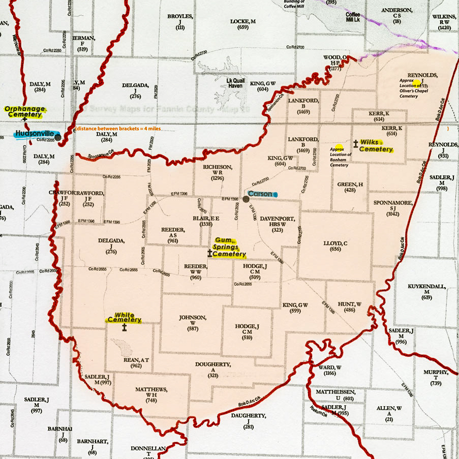
To begin that effort, I pulled all the known burials in Fannin County dating from 1838 to 1852 from the Fannin County GenWeb site. I used these dates because 1838 is the earliest recorded burial in Fannin County and Martin Cagle, the first fully documented burial in the Wilks & Bonham Cemeteries, was buried in 1852.  The initial on-site assessment of the removal team was that the burials to the east of the Cagle row in the Wilks Cemetery were older graves, so my focus was on the period prior to Martin Cagle’s death. My intent was to map the ‘hotspots’ of early Fannin County settlement by locating where the known burials were, hoping that the pattern produced might provide clues as to these early Wilks Cemetery graves. The surnames of other early burials in the area would, I thought, provide good starting points for further research. I used the map of all known cemeteries in Fannin County from the GenWeb site as my starting point. The result for the northeastern part of the County is show below, with the current path of Bois d’Arc Creek highlighted.

Northeast Fannin County Known Burials 1838-1852.jpg

There are a few scattered locations along Red River, and then a concentrated area south and east of Bois D’Arc Creek.  The only known burials in the 1838-1852 time frame along the western side of Bois D’Arc Creek are those at the Wilks Cemetery itself (dark red dot on the map).  The Wilks Cemetery stands conspicuously alone. Certainly there are burial grounds we will never know about where the only markers were wooden posts that have completely disappeared, but it seems likely these would be in proportion to the marked graves that have remained. And perhaps this pattern should not be surprising, illustrating early settlements spreading into the area from the more established communities to the east, overland and along the River.

Studying this map, I began to think about how one would choose a burial ground for a loved one in frontier conditions. If there was a community cemetery in a given location, how wide an area was it likely to serve? What distance was considered nearby, what distance a long journey? To what extent would the area creeks limit travel in a time of few roads? These sorts of questions led me to the creation of another map.

Base map from “Texas Land Survey Maps for Fannin County”, by Gregory A. Boyd, J. D., used with permission of the publisher.

Base map from “Texas Land Survey Maps for Fannin County”, by Gregory A. Boyd, J. D., used with permission of the publisher.

In this one, I highlighted the major creeks (in red) on a map of original land grant awardees, estimating the original course of the creeks prior to the creation of Coffee Mill Lake (in light purple). A ‘basin’ of sorts emerged (highlighted in pink) around the Wilks & Bonham cemeteries. The headright names provide a starting point for the original claimants of the land, and the creeks a reasonable boundary of an extended community.

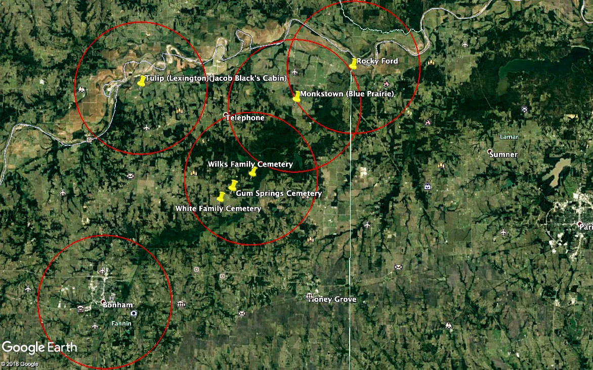
In an attempt to put the ‘basin’ in context within the larger land area and the earliest settlements in Fannin County, and to explore the distances between them, I created a third map. Using the Google Earth app, I drew a five mile radius around key areas. I am told by old-timers from the Carson area, that even in the early 20th century a trip to Bonham was a two day affair in horse-drawn wagon. One day was dedicated to the drive into town and taking care of business. By then it was late, and folks would stay over night then start the journey home the next morning. Given the well established road system at that time, I felt safe in assuming that a five mile journey in an area of few roads would be a significant distance.

Early Settlements_resized.jpg

These maps have given me a lot to think about and a wealth of questions to pursue. They will guide and inform my research going forward as we piece together as much as we can of the story of the Unidentified.

Story by Wanda Holmes Oliver.

The Land that Became the Cemetery

The story of the Wilks Cemetery is a story of the Kerr, Cagle, and Wilks families.  It begins in the earliest days of the Republic of Texas with the arrival of Robert Kerr.

On the basis of his 2nd Class headright, Robert Kerr arrived in Texas with his family between March 3, 1836 and September 30, 1837.  The family included three sons that would claim their own grants.  Yelverton (b. 1814) and Levi (b.1815) were in their early twenties in 1837, and each received 2nd Class land grants themselves as single men.  The grants to Robert, Yelverton, and Levi are recorded in Abstracts #609 (1280 acres), #610 (640 acres), and #606 (640 acres), respectively.  The three tracts are located north of an imaginary line from Ivanhoe to Telephone.  Yelverton’s and Levi’s tracts are adjacent to one another, and Robert’s is a bit to the north.

Son, James (b.1821), would have turned 16 at some point during 1837 - too young to meet the requirement to file as a single man for a 2nd class grant. His is a 3rd class grant issued to single men, 17 years or older, who resided in the Republic of Texas prior to January 1, 1840.  That he claimed his land rights later is also reflected in the fact that the land he gained title to is in multiple parcels, both miles distant from the lands of his father and brothers. James was issued Conditional Certificate #142 on January 2,1840.  Under this certificate, he was entitled to 320 acres of public land in Fannin County.  Conditional certificates were not issued for particular tracts of land, were not negotiable or transferrable, and were predicated on the grantee demonstrating three years of responsible citizenship before applying for the Unconditional Certificate that freed them from all restrictions on ownership.  The grantee had to locate the land he wanted to claim and have it surveyed himself.   Apparently he could stake his claim and exercise all ordinary rights of ownership during the three year conditional period.  As a 3rd Class Grantee, he could also just hold onto the right without having identified or invested in any particular piece of land (4th Class grants required that at least 10 acres of the claimed land be cultivated).

We don’t know when James identified the land he would claim, but he received Unconditional Certificate #150 on May 5, 1845, some five years after receiving his Conditional Certificate.  Under Certificate #150, he was granted patents (title) to two tracts of land at two different times, the first title not being granted until some months after he received his Unconditional Certificate.  It is easy to read into the delay of the Conditional Certificate, and the further delay between it and the first patent, the behavior of a young man growing into adult responsibilities.  But it is equally possible that he had actively claimed and worked his land  from the date of the Unconditional Certificate in 1840.

James’ first patent was to 106 acres located six miles southwest of Bonham.  James received patent to this tract on November 9, 1845. It is recorded in the County records as Abstract #613.  Patent was granted to the remaining 214 acres he was due on February 9, 1846 under Abstract #614.  The Wilks Cemetery is located on this tract, and using the abstract number and the tax rolls, it is possible to trace the ownership of the land that would eventually contain the cemetery as it changed hands over the years. 

Abstract data overlaid on Google Earth image, abstract data from EarthPoint.

Abstract data overlaid on Google Earth image, abstract data from EarthPoint.

James Kerr first appears on the tax rolls of Fannin County in 1843 when he was assessed a poll tax.  In 1845 he was taxed for 320 acres of land and two head of cattle.  He disappears from the rolls in 1846.  His 106 acre tract is, in 1846, in the possession of his brother, Yelverton.  Martin Gaines Cagle is assessed the taxes in 1846 for the 214 acre tract originally patented to James.   I haven’t been able to determine what happened to James after 1846.  While his father and brothers continue to figure prominently in the records of Fannin County, there is no record of him marrying, establishing a family, or owning other property in the county.  He was a young man of 25 - he might have simply sold out and moved on in a quest for greater opportunities. 

The 214 acre tract which now holds the Wilks Cemetery continues to appear on the tax rolls under Martin Cagle’s name for the next several years, passing to Susan Cagle after Martin’s death in 1852.  Though Susan died in 1861, the land is still on the tax rolls under Susan’s name in 1864, with a note that it is registered by her son-in-law, Thomas C. Hale (husband of daughter Frances) as administrator of her estate.  In 1865, the land is listed under the name, Thomas C. Hale, without any additional notes referencing Susan. Susan and Martin Cagle’s sons disappear from the records during the years of the Civil War. Perhaps in 1864 there was still some hope of at least one of them coming home to claim his inheritance. By 1865, the estate had apparently been settled in favor of Frances and her husband.

There is then a gap in the records.  The 1866 tax roll is silent for Abstract #614 and the records for 1867-1876 have not been available for search.  The tract reappears in the rolls for 1877-1879, registered to Matt Wilks and brothers, Newton and Milton Wilks.  This leads to conjecture that the land was sold by Thomas Hale to Thomas Wilks when the Wilks arrived in the area in 1865-866, Thomas’ sons inheriting it from him when he died in 1871.  In the 1880 tax roll, the three brothers are listed as tax payers, but with no land.  Tax is assessed to them based on personal property, horses and cattle.  In 1885, Newton owns a tract out of the M. J. Evans Survey to the southwest of the Wilks Cemetery site.  By 1894, all three brothers own small tracts in that area.  

The next steps in this process are to 1) address the gap mentioned above to confirm the transfer of the land to the Wilks, and 2) to identify who purchased the land from the Wilks. Addressing the gap is going to take some extended legwork. Then there is the 1880 tax roll to search. It comprises some 400+ pages, and the search by abstract number is one I have to do with my eyes, so it must wait for another day as well.  In any case, by 1880, the Cemetery was a well-established burial ground so the specific land ownership is perhaps less informative.  From the point of government owned wilderness to cemetery, the tale of the land is the tale of the Kerrs, the Cagles, and the Wilks.

Story by Wanda Holmes Oliver.